Horizontal curves are indispensable for roadway safety and mobility. Public transportation agencies are exploring efficient and effective approaches to better understand the spatial location, geometrical attributes and conditions of the horizontal curves within their extensive networks of road jurisdiction. With the wide availability of global positioning system (GPS) and geographic information system (GIS) data, some efforts have been made to develop automated algorithms for identifying horizontal curves from GPS trajectories or GIS basemaps. While these methods have shown promising results, they have not been validated or practically applied over large testing datasets with complicated road network connections.
In this study, the research team will continuously process the networks nationwide using the publicly available GIS basemaps, to cover the entire Numbered Highway system in the United States. This gallery of horizontal curve inventories shows the current availability of the results. Please click the link underneath the map for more information. Mileage Completed – 105,343.66 Miles, Mileage under QA/QC – 90,745.10 Miles (as of 2019/8/9).
| State | Routes | Curves | GCS | PCS | Link | Status |
|---|---|---|---|---|---|---|
| Alabama | 257 | 13,650 | EPSG 4269 | EPSG 26929 | Basemap Thumbnail Results | Completed |
| Alaska | 160 | EPSG 4269 | EPSG 26931 | Basemap | QA/QC | |
| Arizona | 149 | 9,624 | EPSG 4269 | EPSG 26948 | Basemap Thumbnail Results | Completed |
| Arkansas | 1,905 | 38,616 | EPSG 4269 | EPSG 26915 | Basemap Thumbnail Results | Completed |
| California | 254 | 36,944 | EPSG 6318 | EPSG 6416 | Basemap Thumbnail Results | Completed |
| Colorado | 296 | EPSG 4269 | EPSG 26913 | Basemap | QA/QC | |
| Connecticut | 408 | 11,983 | EPSG 4326 | EPSG 3857 | Basemap Thumbnail Results | Completed |
| Delaware | 70 | 1,807 | EPSG 4269 | EPSG 26957 | Basemap Thumbnail Results | Completed |
| Hawaii | 140 | EPSG 4152 | EPSG 3750 | Basemap | QA/QC | |
| Illinois | Basemap | Ongoing | ||||
| Indiana | Basemap | Ongoing | ||||
| Kansas | 205 | 4,490 | EPSG 4269 | EPSG 26977 | Basemap Thumbnail Results | Completed |
| Kentucky | 3,380 | EPSG 4269 | Basemap | QA/QC | ||
| Maine | 131 | 7,518 | EPSG 4269 | EPSG 26919 | Basemap Thumbnail Results | Completed |
| Maryland | 479 | 12,095 | EPSG 4269 | EPSG 26985 | Basemap Thumbnail Results | Completed |
| Massachusetts | 171 | 13,422 | EPSG 4269 | EPSG 26986 | Basemap Thumbnail Results | Completed |
| Minnesota | 181 | EPSG 4269 | EPSG 26915 | Basemap | QA/QC | |
| Mississippi | Basemap | Ongoing | ||||
| Missouri | Basemap | Ongoing | ||||
| Montana | 298 | EPSG 4269 | Custom | Basemap | QA/QC | |
| Nebraska | Basemap | Ongoing | ||||
| Nevada | 249 | EPSG 4269 | EPSG 26911 | Basemap | QA/QC | |
| New Hampshire | 125 | 10,639 | EPSG 4269 | EPSG 32110 | Basemap Thumbnail Results | Completed |
| New Jersey | 151 | 4,994 | EPSG 4269 | EPSG 3424 | Basemap Thumbnail Results | Completed |
| New York | 848 | EPSG 4269 | EPSG 26918 | Basemap | QA/QC | |
| North Carolina | Basemap | Ongoing | ||||
| North Dakota | 109 | EPSG 4269 | EPSG 102721 | Basemap | QA/QC | |
| Ohio | 570 | EPSG 4326 | EPSG 3857 | Basemap | QA/QC | |
| Oklahoma | 259 | QA/QC | ||||
| Pennsylvania | 505 | 47,107 | EPSG 4269 | EPSG 32128 | Basemap Thumbnail Results | Completed |
| Rhode Island | 66 | 2,048 | EPSG 4269 | EPSG 32130 | Basemap Thumbnail Results | Completed |
| South Carolina | Basemap | Ongoing | ||||
| Texas | Basemap | Ongoing | ||||
| Utah | 233 | EPSG 4269 | QA/QC | |||
| Vermont | 104 | 10,542 | EPSG 4269 | Custom | Basemap Thumbnail Results | Completed |
| Washington | Basemap | Ongoing | ||||
| West Virginia | 516 | EPSG 4269 | EPSG 26917 | Thumbnail | QA/QC |
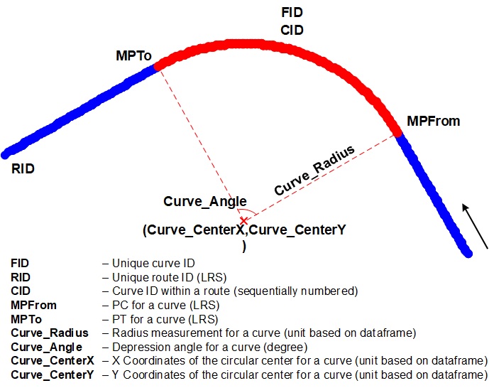
Definition – The curve inventory results will include all the properties that are necessary for safety analysis or other applications. Depending on different basemap formats, the curve inventory will at least include the following attributes and represented based on the corresponding linear reference system.
Citation – If the results and the datasets are used for academic publication, please appropriately cite the basemap data source (as listed in the corresponding result section) and the following paper in the publication.
Ai, C. and Tsai, Y. (2015). ”Automatic Horizontal Curve Identification and Measurement Method Using GPS Data.” ASCE Journal of Transportation Engineering, 141(2), 04014078
Wang, Y., Ai, C., and Qiu, S. (2019). “Development of A Nationwide Horizontal Curve Inventory Using Open GIS Data.” International Conference on Transportation & Development 2019, Alexandria, VA.
Wang, Y., Ai, C., and Qiu, S. (2020). “Development of A Large-Scale Horizontal Curve Inventory for Safety Analysis Using Open GIS Data.” 99th Transportation Research Board Annual Meeting, Washtington DC.
Disclaimer – All the results and information for the horizontal curves on this website were derived ONLY for academic research purposes. The Ai Research Group derived the results based on the publicly available data at the time of processing, but it does not guarantee any changes in the data sharing the policy of the hosting agencies. Please contact the data hosting agencies for more information. The copyright of the data belongs to the data hosting source as the copyright text indicates. The Ai Research Group has internally evaluated and validated the results before it releases any results on this website, but it does not guarantee the quality and the accuracy of the results, nor imply any of its potential applications. Please use the data and the results at your risk, and please use the data ONLY for academic purposes.